
Verification: Predicted 63/90, Actual 66/85
The MCS over Nebraska held together better than expected, permitting clouds to overrun us early this afternoon. At 4:30 pm Eastern, radar storm totals indicates 0.1 to 0.2 inches over east-central Illinois. The rain gauge at Danville, IL disagreed, saying less than 0.05 inches. This might be radar inaccuracy, or it might be that precipitation evaporated on the way down since relative humidity was only 69% at 4 pm. Eventually the lower atmosphere cooled and saturated and we received 0.08″ at Purdue.
So I think my error was expecting the MCS to die out more completely before crossing into Indiana.
This morning’s MCS
First a definition: MCS means mesoscale convective system. Sometimes a few severe storms fire up, then as they move their outflow encourages other storms to form. and eventually you get what looks like a blob of rain and thunderstorms whose size may cover a state. The area of disturbed weather generates its own, counterclockwise surface circulation and barometric pressure at the surface may fall by 2-4 mb.
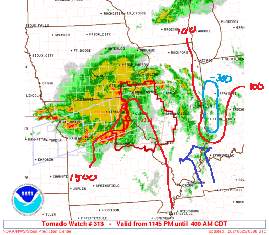
This picture from around 12:30 AM EDT shows a radar mosaic for the mid-Mississippi Valley. The MCS is moving just north of east, in our general direction. In front is a line of storms that have become severe. Within the line, rotation was detected and tornado warnings issued. Some scattered showers and storms are over eastern Illinois as well.
The lines labelled 100 and 1500 show where the SPC, consulting models like NAM and the Rapid Refresh Model, analyzed surface CAPE of 100 J/kg and 1500 J/kg. CAPE under 100 J/kg indicates an atmosphere that is not conducive to the spontaneous development of thunderstorms. They can form. but they must be forced by something like a cold front or a squall line. The light-blue oval labeled -300 indicates where the convective inhibition, or CIN, is particularly strong. Convection over western Indiana. at least for the moment, is suppressed. A high degree of CIN at night is perfectly normal.
The darker arrow pointing NNW shows the direction in which the air is being advected in areas between us and the MCS. If it were pointing from the MCS toward us, that would favor the thunderstorm-friendly surface conditions being pushed our way. As it’s pointing perpendicular to the MCS, other factors will be required to prime the atmosphere over Greater Lafayette.
The SPC stops the SLGT and MRGL severe weather risk areas near the state line, but is that just because the forecast period ends when the MCS is expected to cross into Indiana?
The 00Z (8 pm Thursday) HRRR model predicted a radar signature that looks like the one above, while GFS has most of the action in Iowa and none of it extremely heavy. The bow echo will expand, then begin to break down as it approaches the Indiana line. Lafayette will see a thin line of storms come through, then maybe two or three hours of light to moderate rain around noon.
Tonight’s low will be around 68 F, with a high tomorrow around 76 F. There may be a break in the clouds after 3 pm.
