Category: Default

More heavy rain on the way July 10-?

Here are the various ways the upper atmosphere can make it rain over Indiana.

Friday afternoon, we see a hot dome over the Desert Southwest and a low over northern Quebec. The middle of the atmosphere over us is well primed to trigger the odd shower Friday afternoon into Friday evening. Fortunately the atmosphere will be dry. The meandering 582 hPa isohypse over Manitoba, a pseudopod from the Desert Southwest heat dome, is getting ready to screw with our weather

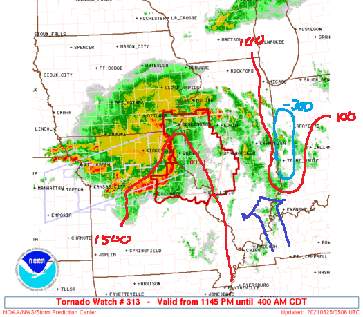
Now watch as the ridge presses northeast into Manitoba. It’s blocked. This is Saturday’s picture, with lots of instability and what GFS believes will turn into a cutoff low digging southwestward through the plains. (What looks like speckling over Missouri is mesoscale activity: a complex of thunderstorms.

This is Sunday evening. A cutoff low has developed over Iowa and Missouri. (The red dashed line at 570 dam hints at the location of the cutoff low. A warm front (where the black isobars show a bulge to the right is placed roughly at US 30. This sort of storm is more like what we would see in the colder half of the year. It also appears to be occluding as the cold front undercuts the warm front, which signals that the low is fated to dissipate.

The low at the surface will weaken as it tracks toward Minnesota. The trough or cutoff low will eject northeastward.

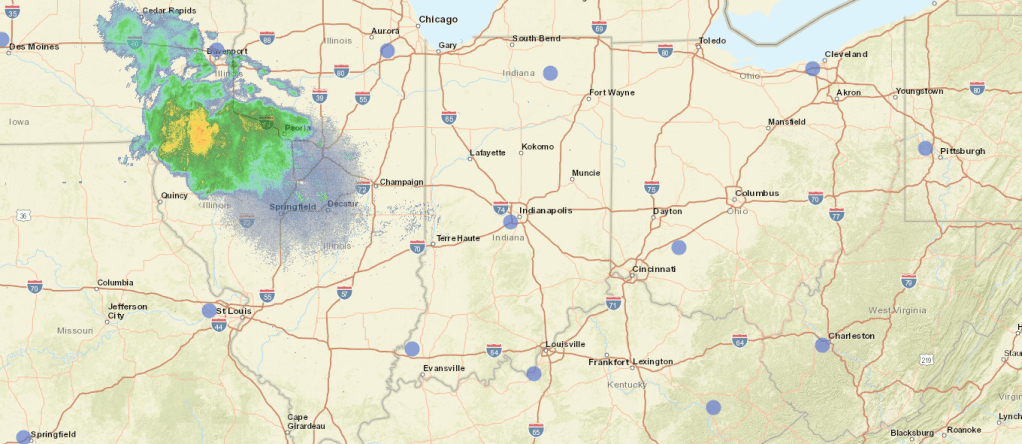
Five models offer five different predictions for the rain through 8 pm Sunday.

Hi-res Euro: 1.5 to 3.5 inches
GFS: 0.7 to 0.9 inches
Canadian: 1.5 to 1.9 inches, with a sharp increase at the Illinois state line.
UKMET: 3 to 5 inches
NAM: 0.5 inches

What they seem to have in common is that actual precipitation will vary quite a bit with location.

So, for us, it looks like temperatures in the 70s, maybe low 80s, no complete rainouts, but lots of showers and thunderstorms, with the possibility that the storms will track each other.

Forecast for June 25

Verification: Predicted 63/90, Actual 66/85

The MCS over Nebraska held together better than expected, permitting clouds to overrun us early this afternoon. At 4:30 pm Eastern, radar storm totals indicates 0.1 to 0.2 inches over east-central Illinois. The rain gauge at Danville, IL disagreed, saying less than 0.05 inches. This might be radar inaccuracy, or it might be that precipitation evaporated on the way down since relative humidity was only 69% at 4 pm. Eventually the lower atmosphere cooled and saturated and we received 0.08″ at Purdue.

So I think my error was expecting the MCS to die out more completely before crossing into Indiana.

This morning’s MCS

First a definition: MCS means mesoscale convective system. Sometimes a few severe storms fire up, then as they move their outflow encourages other storms to form. and eventually you get what looks like a blob of rain and thunderstorms whose size may cover a state. The area of disturbed weather generates its own, counterclockwise surface circulation and barometric pressure at the surface may fall by 2-4 mb.

Storm Prediction Center map of Tornado Watch #313, annotated by WJE

This picture from around 12:30 AM EDT shows a radar mosaic for the mid-Mississippi Valley. The MCS is moving just north of east, in our general direction. In front is a line of storms that have become severe. Within the line, rotation was detected and tornado warnings issued. Some scattered showers and storms are over eastern Illinois as well.

The lines labelled 100 and 1500 show where the SPC, consulting models like NAM and the Rapid Refresh Model, analyzed surface CAPE of 100 J/kg and 1500 J/kg. CAPE under 100 J/kg indicates an atmosphere that is not conducive to the spontaneous development of thunderstorms. They can form. but they must be forced by something like a cold front or a squall line. The light-blue oval labeled -300 indicates where the convective inhibition, or CIN, is particularly strong. Convection over western Indiana. at least for the moment, is suppressed. A high degree of CIN at night is perfectly normal.

The darker arrow pointing NNW shows the direction in which the air is being advected in areas between us and the MCS. If it were pointing from the MCS toward us, that would favor the thunderstorm-friendly surface conditions being pushed our way. As it’s pointing perpendicular to the MCS, other factors will be required to prime the atmosphere over Greater Lafayette.

The SPC stops the SLGT and MRGL severe weather risk areas near the state line, but is that just because the forecast period ends when the MCS is expected to cross into Indiana?

The 00Z (8 pm Thursday) HRRR model predicted a radar signature that looks like the one above, while GFS has most of the action in Iowa and none of it extremely heavy. The bow echo will expand, then begin to break down as it approaches the Indiana line. Lafayette will see a thin line of storms come through, then maybe two or three hours of light to moderate rain around noon.

Tonight’s low will be around 68 F, with a high tomorrow around 76 F. There may be a break in the clouds after 3 pm.

Forecast for June 24

Verification: Predicted 55/85. Actual 63/83

It appears that the night was too cloudy to drop into the 50s. Light southerly winds probably did nothing to cool us off. The daily high was close to the predicted high.

June Monsoon

An extended period of intermittent showers and thunderstorms is expected to run from Friday to Tuesday. The line of storms triggering a tornado watch for Central Nebraska will probably grow into a blob of storms that weakens over southeast Iowa and northeast Missouri. We may get grazed tomorrow midday, but I think it will be mostly high cloudiness.

Temperatures tomorrow will hit 90 F as isolated storms begin over the northwest half of Illinois.

NAM and GFS are at odds over how much rain we will see Friday and Saturday. GFS predicts nearly continual rain Friday and Saturday, with a couple of periods of thunderstorms. NAM pulls what looks like a dying bow echo through Friday forenoon, then some moderate rain will fall Friday afternoon and overnight into Saturday while people along a line from Hannibal MO to Chicago IL and Bay City, MI will see 36 hours of training showers and thunderstorms.

EDIT: GFS’ prediction of widespread, long-duration rain and thunderstorms over the northern half of Indiana is more consistent with its estimate of available moisture than NAM’s. That’s not good news, since GFS suggests that 3-7 inches will fall over Greater Lafayette by 8 am Sunday while NAM expects only 1-2 inches, with higher values to the north (mostly 2-4 inches over the Chicago metro). The Canadian expects 4-5 inches, with some 6+ inches over Route 24 west of Logansport. The UKMET says 1-2 inches for us and 2-3 inches for Hoosiers north of US 24. The Hi-Res Euro dumps 3-4 inches, with values increasing as you go west.

So, for tonight: partly cloudy, low 63. Tomorrow: partly cloudy, slight chance of showers across the Illinois line, highs near 90. Friday-Sunday will see lengthy periods of rain and thunderstorms, but with occasional breaks. Highs will be 80-85 and lows will be around 65.

Forecast for June 23

June 22 forecast was a bust: Predicted 55/68. Actual 53/80.

The main reason for a bust was probably that I trusted the model sounding too much. The GFS sounding showed relative humidities of 100% at 850 hPa (about a mile above sea level) when in fact it was 71% at Lincoln, IL. Wilmington, Ohio peaked near 90% — so it was a “close” call of 200 miles.

Fewer clouds than predicted let temperatures fall freely toward the dewpoint (around 47 F) before dawn though perhaps 2 F of difference is not a bust.

Under bright sunshine for most of the day, temperatures rose to 80 F at Purdue. The Northern Indiana WFO, near Syracuse/North Webster in northeast Indiana, only reached 68 F.

Looking ahead: June 23

NWS radar, Lincoln, IL, 12:35 am EDT June 23.

Not shown on the radar image above are some very light sprinkles along US 24 from Wolcott to Peoria. The precipitation is moving to the east-southeast, so we may get a few drops from the sprinkles now near US 24 and I-57 in Illinois before dawn and a grazing from the disturbance that extends into Iowa later in the day.

Dew points are at 51 F. Cloud cover is not too complete, so a low of 55 F seems likely.

Tomorrow we may get some remnants from the disturbance: light showers in the morning. Then the temperature will rise to the low 80s over most of Greater Lafayette, with the urban heat island and Purdue Airport more likely to see 85.

Beyond June 23: another June Monsoon?

Persistent
High

GFS Model run at 8 pm EDT, from pivotalweather.com

The daily weather setup will not repeat, but like history it will rhyme.

The story this week will be ridge of high pressure to our southwest directing disturbances our way. Over the weekend the ridge to the southwest sill recede as the ridge to the southeast and east expands. Meanwhile it will be the Pacific Northwest’s turn to be smothered by a hot ridge of high pressure. Between the two ridges, a trough will bring delightfully cool weather to the central plains and the northwestern Great Lakes.

For us, it’s the Ring of Fire. The corn will love it, with highs just right. The rest of us will not experience a perpetual rainout: just a series of little disturbances triggering (hopefully) poorly organized, garden-variety thunderstorms.

The Storm Prediction Center suggests that the severe weather will mostly stay in Iowa, though its remnants may stray into the Hoosier State on the 24th and 25th. The SPC believes that there is a risk for severe weather June 26-29, but is not too sure where (“PREDICTABILITY TOO LOW”). Their discussion is basically “Possible activity on Friday from Mid-Mississippi Valley through Southern Great Lakes” for the 25th and subsevere weather most likely in the Ring of Fire for want of strong mid-level winds. In the picture above, the midlevel flow over Indiana is 15-25 knots. Some days will see a little more, some days a little less, but it’s not likely that we’ll see enough to let thunderstorms persist. In short, “splash and dash”

Temperatures will be near seasonal norms: mostly 80s by day, 60s by night

An asterisk for Purdue Airport?

Purdue Airport’s ASOS has been running a little warmer than its neighbors. It did the same last year around this time, running 8-10 F above the neighbors (places like Terre Haute and Danville). Now it tends to run 4-6 F above the nearest statewide reporting stations. It’s not just that Purdue Airport is about 200 feet lower than most of the plain that the Wabash cuts through.

/